


Metro+ (Madrid subway, buses)
Descrizione di Metro+ (Madrid subway, buses)
The most powerful app for finding the best route in Madrid (now also best Metro routes for several cities). Metro+ will make it easy for you: Metro Madrid, bus networks,.... Metro+ offers excelent information so that you cannot get lost. Besides, the "Total route" option collects all public transport obtaining the best itineray, even with walking instructions. You will be always supported by text and maps with a very user-friendly interface and providing the best user experience. Always up-2-date with downloadable DBs.
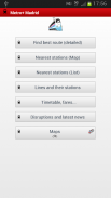
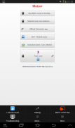
The main features are:
- Metro (several cities):
. Fast math calculations in order to find the best route between 2 stations. You can choose among several Metro networks: Madrid, Barcelona, New York, London, Paris, Rome, etc.... "Metro+" shows you the aprox. time to complete the route. Nearest Metro station search (not for all Metro maps).
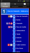
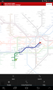
The best route is calculated on the Metro plan tapping both stations (start and destination) or selecting them from the menu "Route". This section has got its own favourites and the best route can also be viewed on a list.
This option does not requiere Internet.
- Metro de Madrid:
. Best route within the Metro de Madrid network. Just select start and end station, time and date (optional) and Metro+ will provide the best itineray. You can add favourites and widgets.
. Network status (+widget), disruptions and news
. 1 way fare
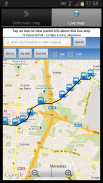
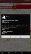
. Map that shows your location and all Metro de Madrid stations. Tapping one station, Metro+ shows you the distance between you and the selected station plus extra information, like pictures, etc... You can also enter a postal address or POI and the distance would be calculated between this entered location and the station. Optional: Metro+ can alert you with notifications of proximity alerts using vibration, LED and text notification when you approach the station (100 m.) or go away from this radious.
. List of stations in 10 km. radious from your location. You can tap a Metro station for more info.
. List of all Metro lines (including Metro Ligero and Metro Sur). Tap a station for info.
. Fares
. Official maps
- Widgets: best route & lines status
- Cercanías (local trains):
. Official Renfe Cercanías app built-in in Metro+: timetable, best route, disruptions, news... (for Madrid and other spanish cities).
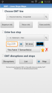
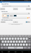
- Madrid EMT buses:
. List of all EMT lines, schematic departure & return maps with itinerary and timetable. Also the paths on a Google map
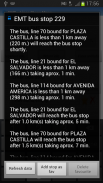
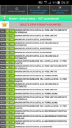
. Waiting times: Provided in real time for all the bus stops (thousands). Just enter the code/number stop and Metro+ will indicate what (line and destination) bus is next that is approaching. You can add favourites, view the picture of the stop, etc... Also you can see the selected stop on a map with traffic status. If you tap on the bus icon, Metro+ shows you the distance between you and the stop. If you enter a postal address or POI, the distance will be between this location and the stop. Optional: Notification of proximity alert when approaching the selected bus stop (100 m).
. EMT disruptions.
- Widget: waiting times for all stops.
. List that shows the nearest bus stops from your location (3 km.) + info of every stop.
. Map & all bus stops + info.
- Urban buses (with next arrival times and also widget) of localities within the "Comunidad de Madrid" like Móstoles, Alcorcón, Fuenlabrada, Alcobendas, etc...
- Suburban buses:
. All lines & maps, itinerary and timetable.
. Complete Info of every line.
. Next arrival times (also widget)
. Disruptions.
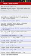
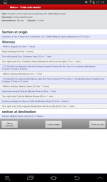
- Total route:
. Best route between two locations taking into account different public transports, waking, etc. You can add favourites and widgets from here. Also you can check the route on a map. Total route is the ultimate way to get the best and fastest route.
- Widget
- Map with bicycle lanes in Madrid.
- Spanish & English.
- Link to "Metro+" chat (Social network & Community for "Metro+" users).
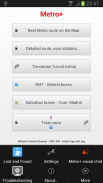
- Lost and Found section
L'applicazione più potente per trovare il miglior percorso a Madrid (ora anche i migliori itinerari della metropolitana per diverse città). Metro + renderà più facile per voi: Metro Madrid, reti di autobus, metropolitana .... + offre informazioni eccellente in modo che non può perdere. Inoltre, l'opzione "percorso totale" raccoglie tutti i mezzi pubblici di ottenere la migliore ITINERARIO, anche con le istruzioni a piedi. Sarete sempre supportati da testi e le mappe con un'interfaccia molto user-friendly e di fornire la migliore esperienza utente. Sempre 2 aggiornato con DB scaricabili.
Le caratteristiche principali sono:
- Metro (diverse città):
. Calcoli matematici veloce, al fine di trovare il percorso migliore tra 2 stazioni. È possibile scegliere tra diverse reti Metropolitana: Madrid, Barcellona, New York, Londra, Parigi, Roma, ecc .... "Metro +" mostra il aprox. tempo per completare il percorso. Ricerca vicina stazione della metropolitana (non per tutte le mappe della metropolitana).
Il percorso migliore è calcolata sulla Metro plan toccando entrambe le stazioni (inizio e destinazione) o selezionandole dal menù "percorso". Questa sezione ha i suoi preferiti e il percorso migliore può essere visualizzato anche su una lista.
Questa opzione non Requiere Internet.
- Metro de Madrid:
. Miglior percorso all'interno della rete Metro de Madrid. Basta selezionare inizio e stazione finale, data e ora (opzionale) e Metro + fornirà la migliore ITINERARIO. Puoi aggiungere preferiti e widget.
. Stato della rete (+ widget di), interruzioni e notizie
. 1 via tariffa
. Mappa che mostra la vostra posizione e tutte le stazioni Metro de Madrid. Toccando una stazione, metropolitana + mostra la distanza tra voi e la stazione selezionata, più informazioni extra, come le immagini, ecc ... È inoltre possibile inserire un indirizzo postale o PDI e la distanza sarebbe calcolata tra questo entrò posizione e la stazione. Opzionale: Metro + può avvisare l'utente con notifiche di avvisi di prossimità mediante vibrazioni, LED e notifica di testo quando ci si avvicina alla stazione (100 m.) O andare via da questa radious.
. Elenco delle stazioni in 10 km. radious dalla vostra posizione. È possibile toccare una stazione della metropolitana per maggiori informazioni.
. Elenco di tutte le linee della metropolitana (compresi Metropolitana leggera di Madrid e Metro Sur). Toccare una stazione per informazioni.
. Fares
. Mappe ufficiali
- Widget: migliore stato percorso e linee
- Cercanías (treni locali):
. Ufficiale Renfe Cercanías app built-in a Metro +: calendario, miglior percorso, interruzioni, notizie ... (per Madrid e in altre città spagnole).
- Autobus Madrid EMT:
. Elenco di tutte le linee di EMT, partenza schematico e tornare mappe con itinerari ed orari. Anche i percorsi su una mappa di Google
. Tempi di attesa: Fornito in tempo reale per tutti le fermate dei bus (migliaia). Basta inserire il codice / numero di stop e Metro + indica che cosa (di linea e destinazione) dell'autobus è accanto che si sta avvicinando. Puoi aggiungere preferiti, visualizzare l'immagine della fermata, ecc ... Inoltre è possibile vedere la fermata selezionata su una mappa con stato del traffico. Se si tocca l'icona autobus, metro + indica la distanza tra voi e la fermata. Se si inserisce un indirizzo postale o POI, la distanza sarà tra questa posizione e la fermata. Optional: Notifica di avviso di prossimità quando si avvicina la fermata del bus selezionato (100 m).
. Interruzioni EMT.
- Widget: tempi di attesa per tutte le fermate.
. Elenco che mostra la più vicina fermate di autobus dalla vostra posizione (3 km.) + Info di ogni tappa.
. Mappa & tutte le fermate degli autobus + info.
- Autobus urbani (con tempi successivi di arrivo e anche di widget) di località all'interno della "Comunidad de Madrid", come Móstoles, Alcorcón, Fuenlabrada, Alcobendas, ecc ...
- Autobus suburbani:
. Tutte le linee e mappe, itinerario e orario.
. Informazioni complete di ogni linea.
. Tempi di arrivo successivo (Widget anche)
. Interruzioni.
- Rotta Totale:
. Percorso migliore tra due posizioni tenendo conto delle differenti mezzi pubblici, la veglia, ecc È possibile aggiungere preferiti e widget da qui. Inoltre è possibile controllare il percorso su una mappa. Percorso totale è il modo migliore per ottenere il percorso migliore e più veloce.
- Widget
- Mappa con piste ciclabili a Madrid.
- Spagnolo e Inglese.
- Collegamento a "Metro +" Chat (Rete sociale e comunitario per gli utenti "Metro +").
- Lost and Found sezione
Metro+ (Madrid subway, buses) - Versione 20.4
(09-04-2020)Metro+ (Madrid subway, buses) - Informazioni APK
Versione APK: 20.4Pacchetto: com.metro.robUltima versione di Metro+ (Madrid subway, buses)
Altre versioni


 3.39
3.39
App nella stessa categoria


Potrebbe piacerti anche...


